Escudo De Veraguas Fm
Type Locality and Naming
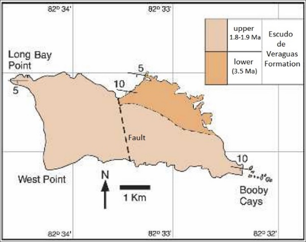
After Coates (1992) named the formation, Coates (1999) carried out more detailed field work that indicated that the coastal section immediately east of Long Bay Point is essentially along strike and thus probably exposes the same sequence of beds several times. A continuous section for the lower part of the formation is best obtained along the coast on the east side of the V-shaped embayment situated in the center of the north coast about 1 km east of Long Bay Point. This locality is now defined as the stratotype for the lower part of the Escudo De Veraguas Fm. The stratotype for the upper part of the formation remains that originally defined by Coates et al. (1992) along the west coast for 1 km south of Long Bay Point. Between these upper and lower stratotypes, both of which have clearly documented physical superposition of strata, there is a small but unknown amount of section missing. The exposures along the north coast of Escudo de Veraguas, immediately east of Long Bay Point, and west of the V-shaped embayment in the center of the north coast, which were part of the original stratotype defined by Coates et al. (1992), are estimated to fall in this gap. However, because the coast is irregular and only approximately parallel to strike, the stratigraphic order of samples from these exposures can not be determined.
[Figure 089. Geological map of Escudo de Veraguas island. Coates et al. (2005).]
Synonym:
Lithology and Thickness
Following 70 m of no exposure, the section continues with 13 m of clayey bioclastic siltstone, with some angular basalt grains, scattered mollusks and cupuladrian bryozoans. The section is massive and pervasively bioturbated with scattered fine shell hash. About 5 m from the top, a second marker horizon is defined by a densely packed coral biostrome that is also rich in echinoids and mollusks. The lower part of the Escudo De Veraguas Fm 2.6-3.5 Ma.
The upper part of the Escudo De Veraguas Fm (Section 10 of Coates (1999)) consists of about 8 m of blue-gray, clayey siltstone and silty claystone, sparsely shelly and intensely burrow-mottled. Thalassinoid-type burrows are common, as are echinoids; the latter are very fragile and almost impossible to collect. Two distinctive marker beds within this section consist of slightly more indurated burrow zones, suggesting minor disconformities or slower depositional rates. It represents onshore and offshore siliciclastic shelf sediments deposited at palaeo-bathymetries of 10-80 m and 100-150 m respectively (Todd & Collins (2005))
Thickness: About 131 m
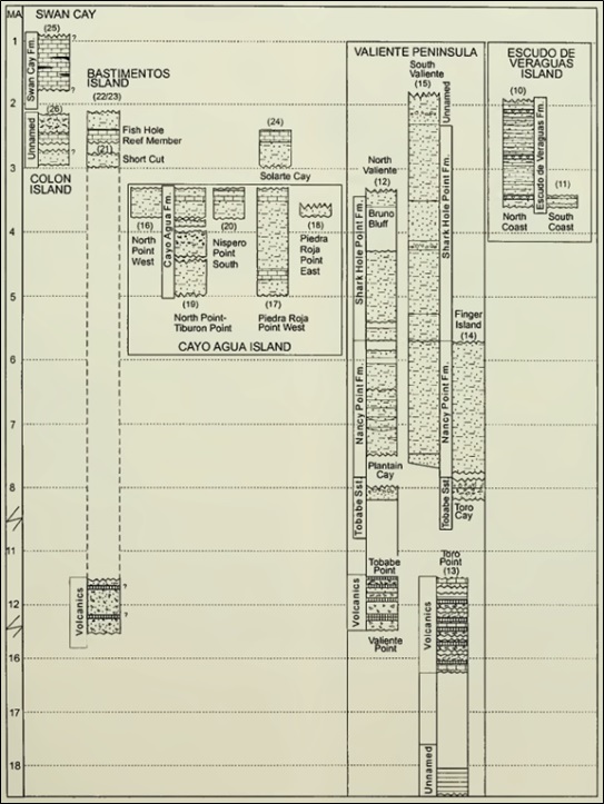
The stratigraphic order of the Tobabe Fm, Nancy Point Fm and Shark Hole Fm (three of the five formations which make up the Bocas Del Toro Gr) has been determined by physical superposition. The two remaining formations of the Bocas Del Toro Gr (Escudo de Veraguas and Cayo Agua) as well as the younger Pleistocene Swan Cay Fm are known only on islands and their position relative to the other units has been determined by biostratigraphic evidence (Figure 044)
Relationships and Distribution
Lower contact
Upper contact
Regional extent
GeoJSON
Fossils
Age
Depositional setting
Additional Information
References:
Coates et al. (1992); Coates (1999); Coates et al. (1992 & 2005); Todd & Collins (2005); Landau et al. (2012a, 2012b); Schwarzhans et al. (2013);

